The Columbia River Gorge from Portland starts about half an hour east of downtown, where the Columbia cuts an 80-mile canyon up to 4,000 feet deep through the Cascade Range. The classic day follows the Historic Columbia River Highway past Vista House and a string of waterfalls to Multnomah Falls, about 30 miles from the city, then continues on I-84 to Cascade Locks and Hood River, about an hour out, before heading home. Without a car, MAX and the Columbia Gorge Express bus reach Multnomah Falls and Hood River seven days a week.
This guide covers the Gorge as a whole: the routes, the towns, the permits and the pace, with the individual waterfalls and trails left to their own guides. The one caveat: the Historic Highway’s western stretch crosses an old slide area that keeps moving, and a section near Vista House was closed for repairs from July to late September 2025, so check the route before you drive it. Road, permit, toll and transit details were checked September 24, 2026 against ODOT, Recreation.gov, Oregon State Parks, the Port of Hood River and the transit operator’s own websites.
On this page: Routes compared · Is the road open? · The classic route · A realistic pace · Sample days · Multnomah Falls permits · Without a car · Gorge towns · The Washington side · Eat and stay · The eastern Gorge · History · By season · Permits and fees · Conditions and safety · Photo tips · FAQ
Which Columbia River Gorge route should you take from Portland?
The Gorge rewards a plan. The Oregon side has the waterfalls and the old highway; the Washington side has quieter viewpoints and Beacon Rock; the eastern end, past Hood River, turns dry and open, with spring wildflowers. Here are the realistic options for a day from Portland.
| Route | Distance and time | Highlights | Best for | 2026 notes |
|---|---|---|---|---|
| Waterfall corridor | About 30 miles to Multnomah Falls; a half day round trip | Vista House, Latourell, Bridal Veil, Wahkeena, Multnomah and Horsetail falls | A first visit or a half day | The section near Vista House sits on an old slide; check TripCheck before you go |
| Waterfalls plus Hood River | About 60 miles each way; a full day | The corridor, Cascade Locks, lunch in Hood River | The classic full day | Multnomah Falls permits only in summer, for the I-84 lot |
| Washington-side loop | About 135 miles round trip | Oregon waterfalls one way, Beacon Rock and SR 14 viewpoints back | A second visit | Bridge tolls: $1.75 to $3.50 at Hood River, $1.25 to $3.00 at Cascade Locks |
| Eastern Gorge | About 85 miles to The Dalles | The Mosier Twin Tunnels trail, Rowena Crest, wildflowers | Spring, and drier weather | Hot in summer; windy all year |
| Mount Hood Loop | About 165 miles round trip | The Gorge, Hood River, then OR 35 and US 26 around Mount Hood | A long summer or fall day | OR 35 can need chains or close in winter |
| Car-free | MAX plus the Columbia Gorge Express | Multnomah Falls, Cascade Locks, Hood River | Travelers without a car | About a dozen buses each way on the 2026 timetable |
Verdict: for a first visit, drive the waterfall corridor, then continue to Hood River for a late lunch and come home on I-84. It’s the most Gorge per hour, and it works in every season. Save the Washington side and the eastern Gorge for a second day.
Is the Historic Columbia River Highway open?
Yes, as of September 2026, but check before you go. The Historic Columbia River Highway (US 30), built between 1913 and 1922 as the country’s first planned scenic highway, climbs from Corbett to Crown Point and then drops through the waterfall corridor to Multnomah Falls and Ainsworth. Its western stretch runs through an ancient slide area that moves up to 12 inches a year. After the settling accelerated in March 2025, the Oregon Department of Transportation closed the section between Larch Mountain Road, by the Portland Women’s Forum viewpoint, and Vista House from July 7, 2025, and reopened it on September 26, 2025; I-84, NE Corbett Hill Road and E Bridal Veil Road served as detours.
If that section closes again when you visit, the fix is simple: stay on I-84 to Exit 28 (Bridal Veil), then drive the Historic Highway west, uphill, to Vista House at Crown Point, turn around and drive back east through the waterfall corridor. You’ll miss the Portland Women’s Forum viewpoint but none of the waterfalls. Check ODOT’s TripCheck the morning of your trip, both for this section and for the landslides, rockfall and ice that can close Gorge roads with little notice.
Vista House itself, the domed 1918 observatory at Crown Point, is free to enter and keeps seasonal hours posted at vistahouse.com. Its parking areas are open 6 a.m. to 9 p.m., and the park closes when winds top 50 mph, which happens more than you’d think at the Gorge’s windy western gate.
The classic route: waterfalls and Hood River
Here’s the full-day version, in order, assuming the Historic Highway is open end to end. If the section near Vista House is ever closed, start at Exit 28 and follow the workaround above.
- Portland to Corbett (about 30 minutes). Take I-84 east and exit at Corbett or Troutdale to climb onto the Historic Highway.
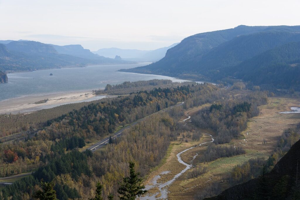
- Portland Women’s Forum and Crown Point. The first viewpoint frames Vista House on its cliff above the river; the second is Vista House itself.
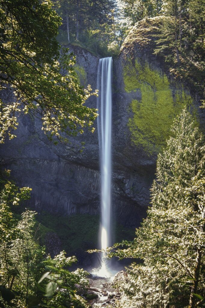
- The waterfall corridor. Drop east past Latourell Falls, Shepperd’s Dell, Bridal Veil and Wahkeena Falls. Pullouts are small; if one is full, move on and catch it on the way back.
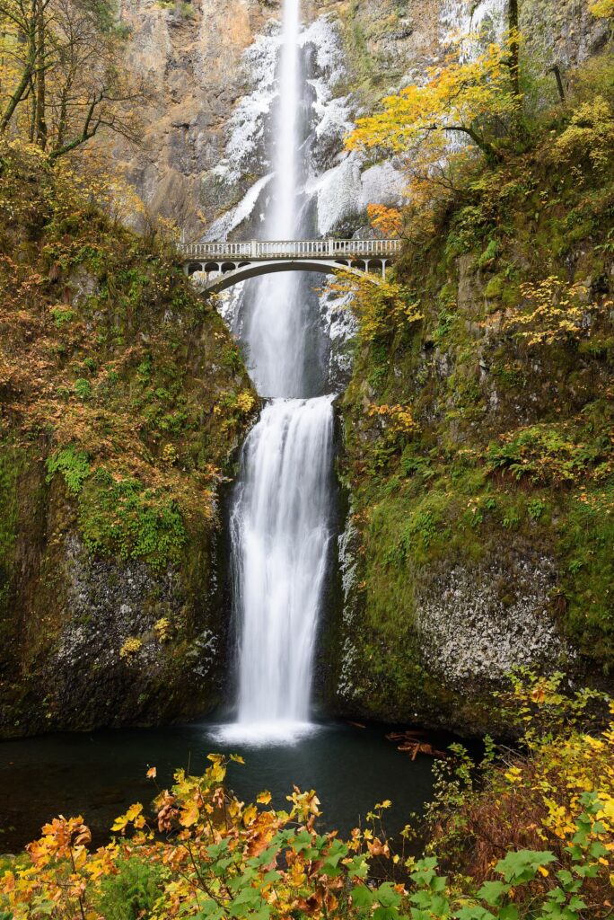
- Multnomah Falls. The Gorge’s headline, a 620-foot, two-tier waterfall with a lodge, a visitor area and a short climb to the Benson Bridge. It’s the busiest stop in the Gorge.
- Horsetail Falls and back to I-84. Horsetail pours down right beside the road; soon after, the old highway rejoins the interstate at Ainsworth.
- Cascade Locks. A small river town at the foot of the Bridge of the Gods, where the Pacific Crest Trail crosses the Columbia.
- Hood River (about an hour from Portland). The Gorge’s main town, with a walkable downtown, a riverfront famous for windsurfing and kiteboarding, and orchards spreading south toward Mount Hood.
- Home on I-84. About an hour back to Portland without traffic.
For how this day fits into a longer stay, our Portland itineraries include a timed Gorge day by car and by bus.
How much of the Gorge fits into one day?
Less than most itineraries suggest. The old highway is narrow and slow, pullouts fill, and every waterfall invites a longer walk than planned. These time budgets assume a moderate pace with short walks at each stop.
| Stop | Allow | Notes |
|---|---|---|
| Portland Women’s Forum viewpoint | 10-15 min | The classic view of Vista House; on the section that closed for repairs in 2025 |
| Vista House at Crown Point | 20-30 min | Free; seasonal hours; closes in winds over 50 mph |
| Latourell Falls | 20-45 min | A short walk to the lower falls view; more for the loop |
| Shepperd’s Dell | 10 min | A short path from the road |
| Bridal Veil Falls | 30-40 min | A short but steep trail to the falls |
| Wahkeena Falls | 15 min | Visible from near the road |
| Multnomah Falls | 45-90 min | Crowds, the lodge, the Benson Bridge |
| Horsetail Falls | 10 min | Right beside the road |
| Cascade Locks | 30-60 min | The Bridge of the Gods and the riverfront park |
| Hood River | 2-3 hours | Lunch, downtown, the waterfront or an orchard drive |
Add driving: about 30 minutes from downtown to Corbett, 20 to 30 minutes along the old highway from Crown Point to Multnomah Falls, about 20 minutes on to Cascade Locks, 25 more to Hood River and an hour home. That makes the full list a nine- to ten-hour day. To keep it relaxed, drop Bridal Veil and Latourell’s loop, or skip Hood River and turn home from Multnomah Falls. For a half day, do Crown Point, two waterfalls and Multnomah Falls, then return on I-84.
Sample Gorge days from Portland
Five ways to shape a day, depending on time, transport and season:
- Half day by car (4-5 hours): Crown Point, two or three waterfalls on the old highway, an hour at Multnomah Falls, back on I-84. Leave by 8 a.m. in summer.
- Full day by car (9-10 hours): the waterfall corridor, Cascade Locks, a late lunch and a stroll in Hood River, then home on I-84 or, in summer and fall, around Mount Hood on OR 35 and US 26.
- Car-free day: MAX to Gateway, an early Columbia Gorge Express to Multnomah Falls, a later bus on to Hood River for lunch, and an afternoon bus back. Check the timetable so the last leg leaves margin before the final departure.
- Second visit: Oregon’s waterfalls east in the morning, across the Hood River Bridge to White Salmon, and back west on Washington’s SR 14 past Beacon Rock.
- Spring day in the east: I-84 to Hood River, the Twin Tunnels trail toward Mosier on foot or by bike, then the old highway to Rowena Crest for the wildflowers.
Do you need a permit for Multnomah Falls?
Only in summer, and only for one parking lot. In 2026, a timed use permit was required from May 22 to September 7 to park in the I-84 lot at Exit 31 between 9 a.m. and 6 p.m. It cost $2 plus a $2 Recreation.gov transaction fee per vehicle, and it gave permission to park if a space was open rather than reserving one; the lot has 186 spaces. No permit was required on the Historic Highway approach in 2026. Outside the permit season, both approaches are first come, first served.
Three tips: arrive before 9 a.m. or after 5 p.m. in summer, when the lot is least crowded; visit on a weekday if you can; and in the off-season, expect weekend crowds anyway, because Multnomah Falls is one of Oregon’s most visited sights. Check Recreation.gov in spring for the 2027 season’s dates and rules, which can change year to year.
Can you visit the Columbia River Gorge without a car?
Yes, for the main stops. Take a MAX Red, Blue or Green Line train to Gateway Transit Center in Northeast Portland (a $2.80 TriMet fare, capped at $5.60 a day) and transfer to the Columbia Gorge Express, which runs seven days a week to Troutdale, Multnomah Falls, Cascade Locks and Hood River. Its spring 2026 timetable, still posted in September, listed about a dozen trips in each direction, with the first bus leaving Portland at 7:20 a.m. and the last one back from Hood River at 6:40 p.m. Buy tickets through the Token Transit app or as a GOrge Pass, and check the operator’s fare page for current prices.
Two limits to plan around. In extreme congestion, the bus can skip the Multnomah Falls stop, so ride an early one on summer weekends. And the smaller waterfalls on the old highway, Vista House and the Washington side aren’t on the bus route; to see them without driving, join a small-group tour from Portland.
Cyclists have another option. Car-free sections of the Historic Columbia River Highway State Trail follow the old road where it was bypassed by the interstate, the best known between Hood River and Mosier through the Mosier Twin Tunnels. Our guide to getting around Portland covers the MAX leg and TriMet’s fare rules in detail.
The Gorge’s towns
Troutdale and Corbett
Troutdale, at the Sandy River just east of Portland, is the Gorge’s western gateway and the start of the Historic Highway; it’s also a Columbia Gorge Express stop. Corbett, up on the bluff, is the rural community below Crown Point, with the road’s first big viewpoints.
Cascade Locks
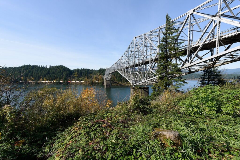
Cascade Locks sits beside the Bridge of the Gods, the steel toll bridge to Washington where the Pacific Crest Trail crosses the river. It’s a quiet stop with a riverfront park, a good place to stretch your legs between Multnomah Falls and Hood River, and a Gorge Express stop.
Hood River
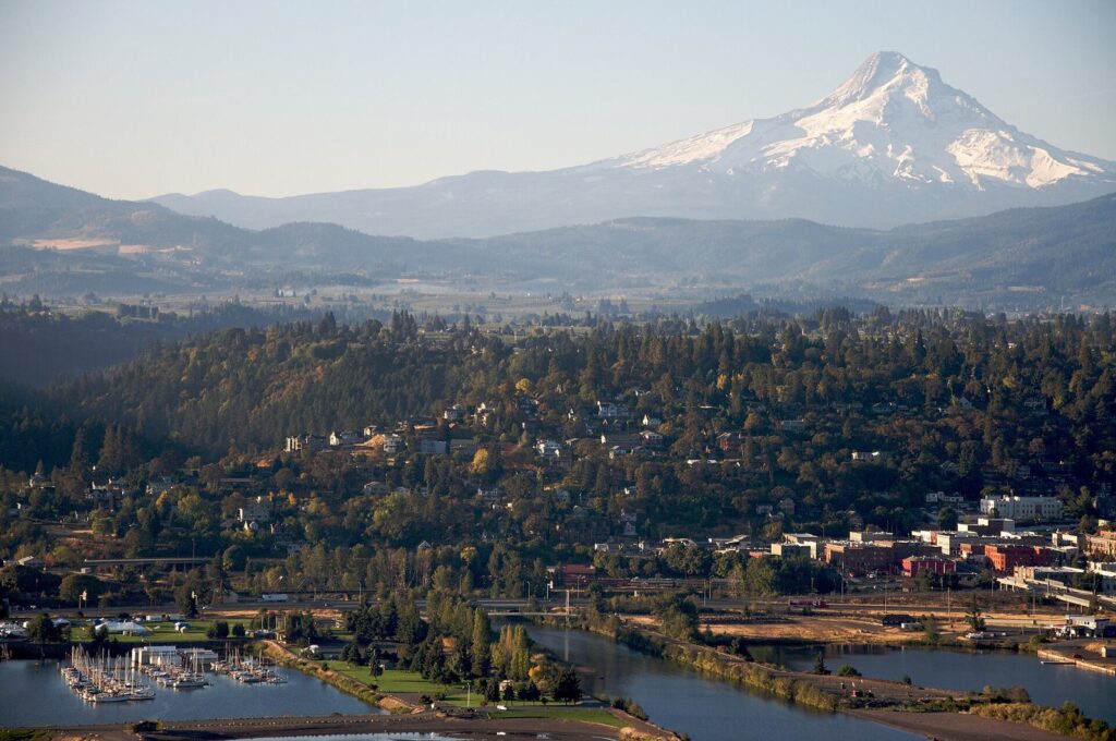
Hood River is the Gorge’s hub: a walkable hillside downtown of restaurants, breweries and shops, a waterfront where the Gorge’s steady winds make it a center for windsurfing and kiteboarding, and the Hood River Valley’s orchards spreading south toward Mount Hood. The Fruit Loop, a signed drive of about 35 miles through the orchards and farm stands, is at its best from late summer through the fall harvest. Hood River County is also one of Oregon’s rural counties where you can pump your own gas at any station, any hour.
Mosier and The Dalles
East of Hood River the climate turns drier fast. Mosier is a tiny town at the end of the car-free Twin Tunnels trail, and The Dalles, about 85 miles from Portland, marks the Gorge’s eastern end, with the Historic Highway’s Rowena Loops and Rowena Crest viewpoint between them.
The Washington side: SR 14 and Beacon Rock
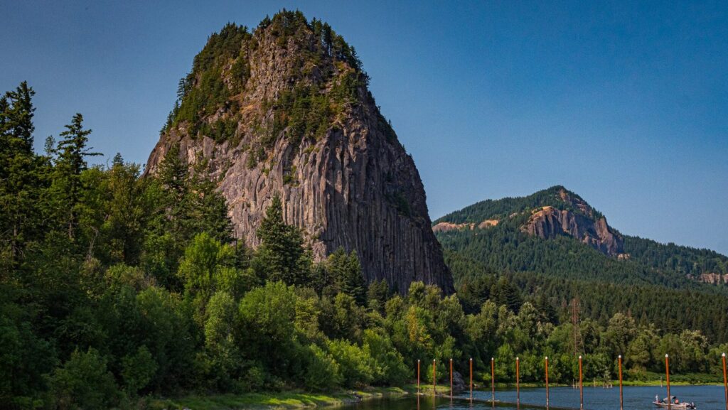
Across the river, Washington State Route 14 runs the length of the Gorge on the north bank, with fewer crowds and some of the best views back toward the Oregon cliffs. The headline stop is Beacon Rock, a sheer volcanic core rising straight from the riverbank, in a Washington state park that requires Washington’s Discover Pass for parking. Stevenson and Carson, farther east, and White Salmon and Bingen, across from Hood River, are the main towns.
A Washington-side loop makes a good second Gorge day: drive the Oregon waterfalls east to Hood River, cross the Hood River Bridge to White Salmon, then return west on SR 14 past Beacon Rock to Vancouver and back into Portland. Both Gorge crossings charge tolls in 2026:
| Bridge | With a BreezeBy tag | Without a tag | Connects |
|---|---|---|---|
| Bridge of the Gods | $1.25 | $3.00 | Cascade Locks and Stevenson |
| Hood River-White Salmon Bridge | $1.75 | $3.50 | Hood River and White Salmon/Bingen |
The Port of Hood River is moving to all-electronic tolling, charged by tag or by license plate, so don’t count on paying cash at a booth; one BreezeBy transponder works on both bridges.
Where to eat and stay in the Gorge
Hood River has the Gorge’s widest choice of restaurants, cafes and brewpubs, clustered in its compact downtown and along the waterfront, so it’s the natural lunch stop on a full-day loop. Cascade Locks and The Dalles have smaller selections, and the historic lodge at Multnomah Falls is the one sit-down stop in the waterfall corridor itself. Pack water and snacks for the old highway, where there’s little else between Corbett and Multnomah Falls.
Most visitors treat the Gorge as a day trip from Portland, and a base on the city’s east side puts you closest to I-84; our guide to where to stay in Portland compares areas. Staying a night in Hood River changes the trip: you can see the waterfalls in early morning light before the crowds, drive the Fruit Loop at an easy pace or add the eastern Gorge and Mount Hood the next day. Oregon’s state lodging tax is 1.5% for stays ending by December 31, 2026 and 2.75% after that, plus local taxes.
The eastern Gorge: Rowena Crest and the Twin Tunnels
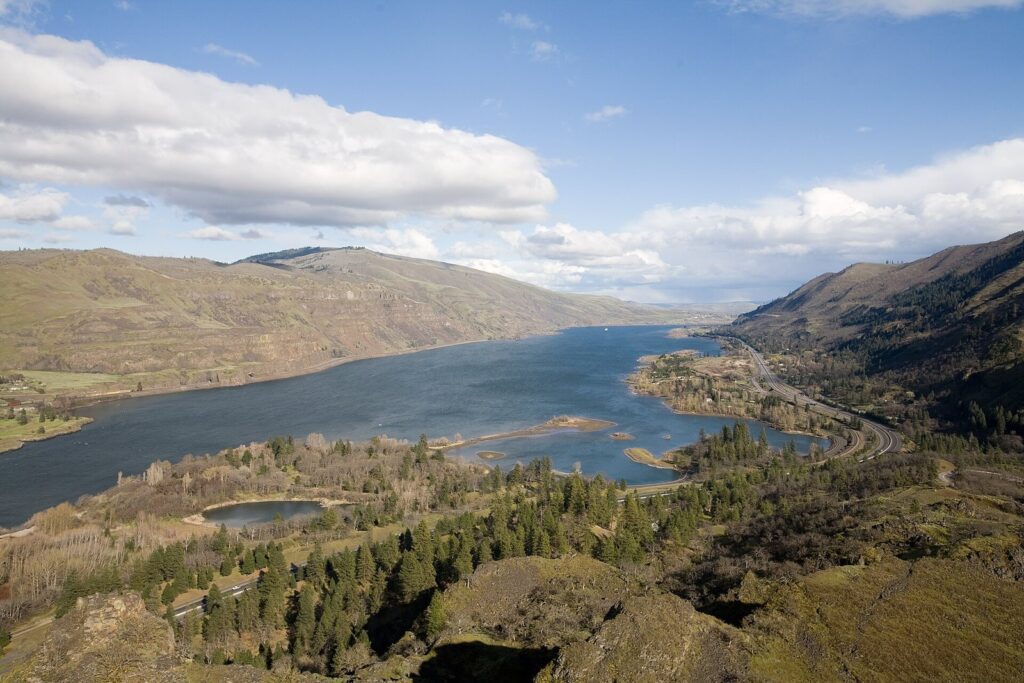
The Gorge’s eastern third feels like a different state. Past Hood River, the forest thins to oak, pine and grass, the rain shadow of the Cascades cuts rainfall sharply, and summer afternoons run hot. The Historic Highway resumes east of Mosier and climbs the Rowena Loops to Rowena Crest, a viewpoint above the river famous for its spring wildflowers, usually at their best in April and May. For cyclists and walkers, the car-free Historic Columbia River Highway State Trail between Hood River and Mosier passes through the Mosier Twin Tunnels, carved for the original highway. Combine them for a spring day, or add them to the Mount Hood Loop in summer.
A short history of the Gorge
The Gorge was carved over millions of years as the Columbia cut through the rising Cascades, and finished dramatically at the end of the last ice age, when repeated floods from glacial Lake Missoula tore down the river and scoured its walls. Those floods left the side valleys hanging high above the river, which is why so many streams now pour over the cliffs as waterfalls.
The river has been home to Native peoples for thousands of years, and it still is. The Columbia River treaty tribes (the Confederated Tribes of the Warm Springs, the Confederated Tribes and Bands of the Yakama Nation, the Confederated Tribes of the Umatilla Indian Reservation and the Nez Perce Tribe) hold treaty fishing rights on the river, and tribal fishers still work from platforms and boats along its banks; the Columbia River Inter-Tribal Fish Commission is the place to learn about that fishery. Celilo Falls, east of The Dalles, was one of North America’s great fishing and trading places for millennia until The Dalles Dam flooded it in 1957.
Lewis and Clark passed through in 1805 and again in 1806. The Historic Columbia River Highway followed between 1913 and 1922, Bonneville Dam in 1938, and in 1986 Congress created the Columbia River Gorge National Scenic Area to protect the landscape on both banks.
When is the best time to visit the Columbia River Gorge?
| Season | Why go | Watch for |
|---|---|---|
| Spring (March-May) | Waterfalls at full flow; wildflowers in the eastern Gorge; fewer crowds | Rain on the west end; the permit season starting in late May (May 22 in 2026) |
| Summer (June-August) | Dry weather, long days, the whole Gorge open | Crowds, Multnomah Falls permits for the I-84 lot, heat in the east, wildfire smoke late in the season |
| Fall (September-November) | Fall color, harvest on the Fruit Loop, no permits after early September | The first storms and wind by November |
| Winter (December-February) | Waterfalls running high, quiet trails, occasional ice formations | East winds, ice storms, I-84 and Historic Highway closures, wind closures at Vista House |
For how the Gorge fits into Portland’s year, including rain days and daylight by month, see our guide to the best time to visit Portland.
Permits, passes and fees in the Gorge
| Fee or pass | Where it applies | 2026 details |
|---|---|---|
| Multnomah Falls timed use permit | The I-84 Exit 31 lot, 9 a.m.-6 p.m., in season | $2 plus a $2 fee; May 22-September 7, 2026 |
| Oregon State Parks day-use permit | State parks where posted; more parks added in March 2026 | $10 a day for residents, $12 for visitors |
| Northwest Forest Pass or other federal pass | Many Forest Service trailheads | Check the sign at each trailhead |
| Washington Discover Pass | Washington state parks, including Beacon Rock | Check the Washington State Parks site |
| Bridge tolls | Bridge of the Gods; Hood River-White Salmon Bridge | $1.25-$3.00 and $1.75-$3.50 |
Vista House is free, and so is the Historic Highway itself. The real costs of a Gorge day are fuel, lunch and whatever fees apply at the trailheads you choose; the Gorge Express and the MAX leg replace the fuel for travelers without a car.
Road conditions and safety in the Gorge
- Check TripCheck every time. Landslides, rockfall, ice and wind close the Historic Highway and sometimes I-84, as the 2025 closure near Vista House showed.
- Respect the wind. The Gorge funnels air between eastern Oregon and the coast. Winter east winds make it much colder than Portland, and Vista House closes in winds over 50 mph.
- Stay on trails and behind railings. Cliffs above the waterfalls are steep and slippery when wet; the 2017 Eagle Creek Fire also left loose ground in places, so obey trail closure signs.
- Expect dead zones. Cell coverage drops in parts of the Gorge; download maps before you leave.
- Fuel before the long drives. Self-serve is legal around the clock in Hood River and Wasco counties; in Multnomah County, stations may offer self-serve at up to half their pumps, at the same price as the attended ones.
Families will find the Gorge easy with young children if they stick to the short, paved or roadside stops: Vista House, Wahkeena, Horsetail and the lower viewpoint at Multnomah Falls. Our guide to Portland with kids covers more family day trips.
Tips for photographing the Gorge
- Waterfalls like clouds. Overcast days give soft, even light on the falls; bright sun leaves harsh contrast in the canyons.
- Viewpoints like clear air. Save Crown Point, Rowena Crest and the Washington-side overlooks for clear days, early or late, when the light rakes along the cliffs.
- Beat the crowds at Multnomah Falls with an early start; by late morning the bridge and viewing areas fill.
- Spring is the eastern Gorge’s season, when wildflowers cover the slopes around Rowena Crest; fall brings color to the waterfall corridor’s maples.
- Winter cold snaps can freeze the waterfalls into ice sculptures, but the same conditions ice the roads and close them; check TripCheck and don’t chase ice photos on closed roads.
Columbia River Gorge from Portland FAQ
How far is the Columbia River Gorge from Portland?
The western Gorge begins about 30 minutes east of downtown. Multnomah Falls is about 30 miles away, Cascade Locks about 45 and Hood River about 60, roughly an hour on I-84 without traffic. The Dalles, at the eastern end, is about 85 miles, and a full loop around Mount Hood via Hood River runs about 165 miles.
Can you see the Gorge in half a day?
Yes. Drive to Crown Point, stop at two or three waterfalls on the old highway, spend an hour at Multnomah Falls and return on I-84, about four to five hours in all. Without a car, the Columbia Gorge Express to Multnomah Falls and back fits a half day too, as long as you catch an early bus in summer.
Is the Historic Columbia River Highway open now?
Yes. The section between the Portland Women’s Forum viewpoint and Vista House, which sits on an ancient slide, was closed for repairs from July 7 to September 26, 2025 and has been open since. If it closes again, reach Vista House from the east via I-84 Exit 28 and the old highway. Check TripCheck on the day.
Do you need a permit to visit Multnomah Falls?
Only to park in the I-84 lot between 9 a.m. and 6 p.m. during the summer permit season, which ran May 22 to September 7 in 2026; the permit cost $2 plus a $2 fee. No permit was needed on the Historic Highway approach, and none is needed outside the season. Check Recreation.gov for the 2027 dates.
Can you drive the Historic Columbia River Highway in winter?
Usually, but conditions change fast. East winds, ice storms and snow can close the old highway and even I-84 for a day or more, and Vista House closes when winds top 50 mph. On a mild winter day the waterfalls are running high and the trails are quiet. Check ODOT’s TripCheck before leaving, and carry traction devices if ice is forecast.
Is the Oregon or Washington side of the Gorge better?
For a first visit, the Oregon side: it has the waterfall corridor, Vista House, Multnomah Falls and Hood River. The Washington side, along SR 14, is quieter, with Beacon Rock and wide views back across the river. A loop using both, crossing at Hood River or Cascade Locks, makes a good second day.
What is the best town to visit in the Columbia River Gorge?
Hood River, about an hour from Portland. It has the Gorge’s best choice of restaurants and breweries, a walkable downtown, a busy windsurfing and kiteboarding waterfront, and the Fruit Loop orchard drive, and it’s a stop on the Columbia Gorge Express. Cascade Locks is the smaller, quieter stop on the way.
Related Portland Guides
- Day Trips from Portland, Oregon: how the Gorge compares with the coast, Mount Hood and wine country.
- Portland, Oregon Itinerary: a timed Gorge day by car or by bus inside a longer trip.
- Getting Around Portland, Oregon: MAX to Gateway, fares and caps.
- Best Time to Visit Portland, Oregon: weather by month and the year’s events.
- Where to Stay in Portland, Oregon: bases on the east side, closest to I-84.
Sources and verification
Road status, permits, tolls and transit details on this page were checked on September 24, 2026 against the agencies and operators listed below. The guide is compiled from those sources and claims no first-hand visits.
- ODOT TripCheck
- ODOT: Multnomah Falls (I-84) timed use permit
- Recreation.gov: Columbia River Gorge timed entry
- Oregon State Parks: Vista House
- Vista House at Crown Point
- Oregon State Parks: day-use parking permits
- USDA Forest Service: Columbia River Gorge National Scenic Area
- Columbia Area Transit: Columbia Gorge Express
- TriMet fares
- Port of Hood River: toll rates
- Oregon State Fire Marshal: self-serve fueling
- KGW: Historic Highway closure near Vista House
- Columbia River Inter-Tribal Fish Commission
- Oregon Department of Revenue: state lodging tax
Portland Tourism Guide is an independent publication, not affiliated with Travel Portland, the City of Portland or any business named here.
Photo credits
- Columbia River Gorge from Rowena Crest: photo by Cacophony, Wikimedia Commons (CC BY 3.0)
- Columbia River Gorge from Crown Point: photo by King of Hearts, Wikimedia Commons (CC BY-SA 4.0)
- Latourell Falls: photo by Steven Pavlov, Wikimedia Commons (CC BY-SA 4.0)
- Multnomah Falls: photo by King of Hearts, Wikimedia Commons (CC BY-SA 4.0)
- Bridge of the Gods: photo by King of Hearts, Wikimedia Commons (CC BY-SA 4.0)
- Hood River and Mount Hood: photo by Sam Beebe, Wikimedia Commons (CC BY 2.0)
- Beacon Rock: photo by cascadevideoproductions, Wikimedia Commons (CC BY 2.0)